
Dana Gaines
Saturday, June 14, 2014
Hello and welcome to my training blog for the planned August 9, 2014 circumnavigation-by-kayak of Martha’s Vineyard as a fundraiser for the famous Gay Head Lighthouse, which must be moved back within a year to avoid toppling over the equally famous Gay Head Cliffs. If weather permits on that day, I’ll start off the lighthouse at 5:30AM and proceed clockwise or counter-clockwise around the island– a choice which will be made based on the forecast wind direction and speed for the next 12 hours. If conditions are favorable, I’ll hope to finish by mid-to-late afternoon, and ideally beat the ’round-MV record of 11 hours and 4 minutes which two friends and I set in Sept. 2012.
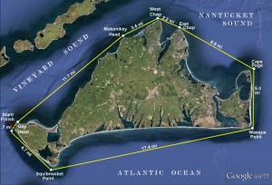
Proposed kayak circumnavigation route
The route is 52 miles long following the straight lines between eight GPS waypoints– although some deviation due to wind and waves will be inevitable. August 9th was chosen as it offers beneficial tidal currents in Vineyard and Nantucket Sounds during the time I’ll be transiting those water bodies– and favorable currents are absolutely essential to efficient passagemaking in kayaks. In a nutshell, as the tide rises in the open Atlantic, it begins to “flood” like a river up into Nantucket Sound via Vineyard Sound on the west side of the island, and the Muskeget Channel to the east of Chappaquiddick; once Nantucket Sound is full and the tide begins dropping in the Atlantic, the currents reverse and roar back out (“ebb”) from whence they came, with the full cycle taking slightly over 12 hours. Timed properly, a kayak can pick up more than 2 mph of current assist on average, and double that speed passing headlands.
In either direction, by maintaining a relatively relaxed paddling speed of 5.5 mph, I should be able to capitalize on the flood current in the early stages of the trip, and if Cape Poge on Chappaquiddick can be reached by 9:30-10AM, catch the shift and get a boost from the ebb for the second half. Given that the prevailing wind is from the southwest in summertime, it’s most likely that I’ll go counter-clockwise with the wind behind me for the long ocean leg early, round Cape Poge and pick up the strengthening ebb current around East and West Chops, then down Vineyard Sound in the afternoon; while I’ll have to paddle the final leg into the wind no matter which direction I go, having a 2 mph current assist down the Sound will hopefully counteract the debilitating effect of the headwind (current is negligible on the Atlantic side of the Vineyard; I would only paddle clockwise if the wind happens to be out of the east that day).
That’s enough detail for now…. reflections on how to prepare for a trip of this distance and duration will follow!